The rocks on the shoreline of Ballymoney were formed, essentially over two periods, separated by millions of years. Essentially the same type of rock, slates and shales, the lower layer tends to be diagonal to the vertical, whilst the upper layer is more vertical. There are deposits of different types of rock, including granites and limestones, most probably deposited by alluvial movement. There is one notable deposit and its origin remains a mystery to this day (see inset). Over the decades and possibly the last few centuries, rocks, beaches and walkways have been named, a number of them simply as a result of the family who once lived there or a ship that came ashore.
Starting at the south end of Ballymoney front (south) beach, the following are the recorded names of rocks, features and walks going north all the way to Saleen. We start with Fanning’s Rock, directly under “The White House”. At very low tides, on a spring tide it is possible to walk around this rock, but only a few times a year. Immediately north of Fanning’s Rock there is a type of inlet, known as “The Sheep Hole”.
Whilst we have no idea how, it is believed that sheep were dipped there in the Summertime before the arrival of locally constructed manmade sheep dips. Moving north along the front beach, and at its most northerly point we have the “Kettle”. The Kettle is a mass of craggy rocks, only visible on low tides, but the sea waters can be seen to be “disturbed” on any tide.
Moving north again and all the rock formations between the south and north beaches are known as the “Pump” rock. The Pump Rock is not a single outcrop, as many believe, but all the rocks in this location.
As we walk along Ballymoney north beach, just past where the first dance hall was located, a small stream comes onto to the beach. Today there is a new entrance from Sandy Cove and Sandy Lane. The streamed area was originally known as “Mary Gorman’s Glen” and the original walkway known as the “Frolic”. Mary Gorman is known to have lived there in the early part of the 20th Century.
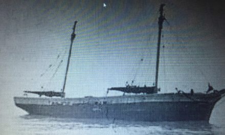
We continue on our walk along the north beach and immediately just south of where the Issallt foundered we have “Owen’s Rock”, commonly misnamed the Isallt rock. Owen’s Rock, a reddish/brown standalone rock was often used for private sunbathing by sparsely dressed sun worshippers.
There is a small beach immediately after The Isallt. This is “Borrough Strand”. The strand derived its name from the land above it, which was overrun by rabbits and their numerous borroughs.
Immediately to the north, there is an outcrop of rock, which, at low tides, we can walk around without getting wet. This is known as “The Twin Hole” and once around this little outcrop we come onto “The Glen Strand”, below Nick and Micheal Redmond’s holdings.
We then come to where the dredger came to shore. It’s resting place is “The Red Rock”, followed shortly by “Peter’s Rock”, named after a Mr Peter Waters, who lived on the headland just above it, date unknown.
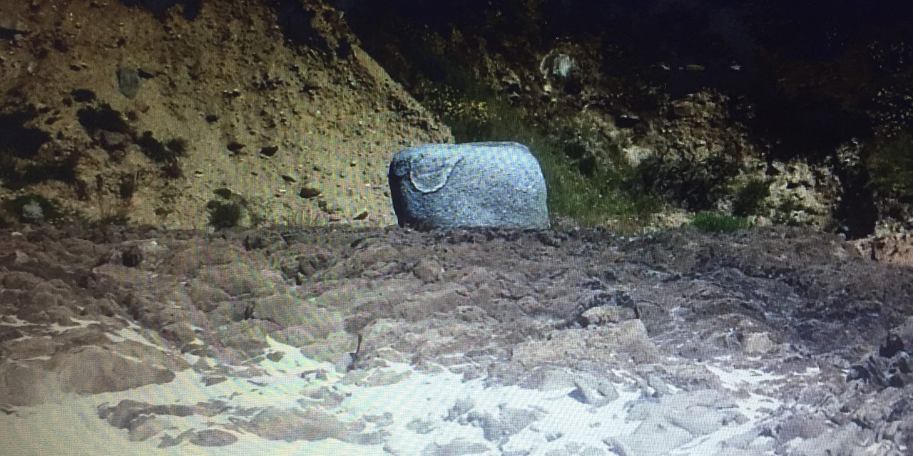
On we go further north and we come to the unusual rock, mentioned earlier. This is a white boulder resting on top of the rock strata below. Known as “The White Bull”, how it actually got there remains a mystery to this day. It has also been referred to as “The Captain’s Chair”.
There is a rock in the sea just out from “The White Bull” and this is the “Keg” and inland we have “Longman’s Path” and “Long Head”. A little further north we come onto “Noctor’s Beach” and “Noctor’s Head”.
Along a fine stretch of beach now, where an entrance was formed in the recent past, we are on “Devine’s Beach”. Sadly a “stack” which we should all remember is now gone but was known as “G Rock” and then we come to “The Arch Hole”, towards the caves.
Not too far from Saleen strand now, we arrive at “Salt Rock”, the site of the ill-fated Ullswater. Before arriving at Saleen, we come across “The Churn Hole” and the “Isarella”, where the ship of the same name sank sometime in the distant past.


